Harris Avenue Utility and Multimodal Safety Improvements
Share Harris Avenue Utility and Multimodal Safety Improvements on FacebookShare Harris Avenue Utility and Multimodal Safety Improvements on X (formerly Twitter)Share Harris Avenue Utility and Multimodal Safety Improvements on LinkedinEmail Harris Avenue Utility and Multimodal Safety Improvements link
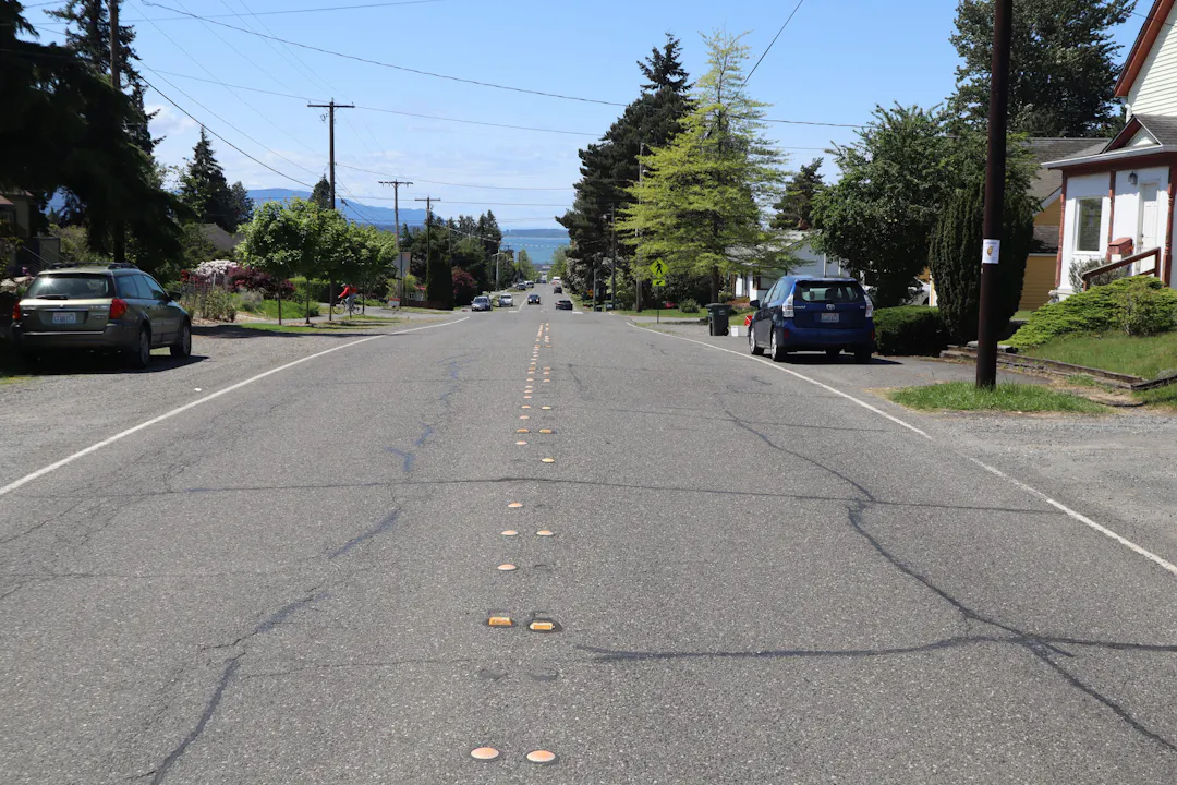
Help guide the future of Harris Avenue
The City is planning improvements on Harris Avenue between 14th and 24th Street and we'd like your input. We’re evaluating between two options: protected bike lanes on both sides (Option A) or a shared‑use path on the south side (Option B). Early analysis shows that Option B will reduce costs and construction impacts while providing similar levels of safety and comfort. Before making a final selection, we’re checking in to understand which option you prefer and what we should prioritize in the design. Please share your feedback by November 15 using the SurveyContinue reading
Help guide the future of Harris Avenue
The City is planning improvements on Harris Avenue between 14th and 24th Street and we'd like your input. We’re evaluating between two options: protected bike lanes on both sides (Option A) or a shared‑use path on the south side (Option B). Early analysis shows that Option B will reduce costs and construction impacts while providing similar levels of safety and comfort. Before making a final selection, we’re checking in to understand which option you prefer and what we should prioritize in the design. Please share your feedback by November 15 using the Survey and Questions tools below. Full project details are available on the Harris Avenue Multimodal Improvements project webpage.
Why this project is happening and how your input matters
The City needs to replace aging water and sewer pipes under Harris Avenue. Once the pipes are replaced, we will have to restore the roadway. During this process, we have an opportunity to improve safety and mobility for everyone who uses the street by implementing high priority projects identified in the 2024 Pedestrian and Bicycle Master Plans. Combining safety improvements with needed utility upgrades helps reduce overall costs and minimize environmental impacts.
The project team developed and evaluated several possible designs, which we’ve narrowed down to two finalists. Our initial review shows that Option B (shared-use path) will significantly lower costs and reduce construction impacts compared to Option A (separated bike lanes) while offering similar improvements to safety. Since Option B differs from the original recommendation for this corridor in the Bicycle Master Plan, we want your input on which option you believe will best meet the needs of our community.
As we evaluate these options, we are balancing key priorities such as project cost, impacts to nearby properties, safety improvements, on‑street parking, placemaking opportunities, and consistency with City plans. Your input is a critical part of this process. By filling out the Survey and Question tools below you can help shape the final design for this important piece of our transportation network.
Share Option A: Separated Bike Lanes on Both Sides on FacebookShare Option A: Separated Bike Lanes on Both Sides on X (formerly Twitter)Share Option A: Separated Bike Lanes on Both Sides on LinkedinEmail Option A: Separated Bike Lanes on Both Sides link
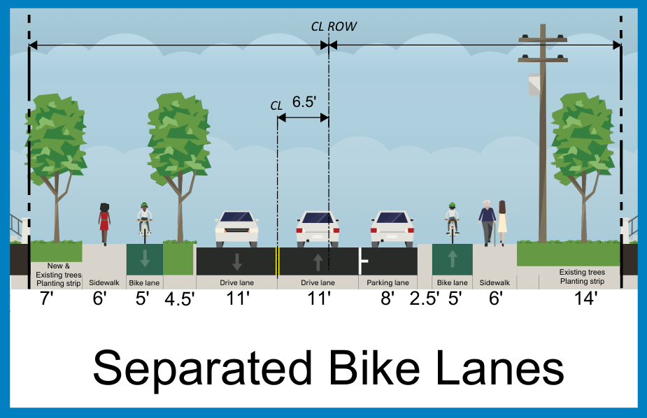
Adds protected bike lanes from 14th to 24th Street
Sidewalks and bike lanes on both sides of the street
A buffer separates people biking from vehicle traffic
Matches the Bicycle Master Plan recommendation for this corridor
Provides more on-street parking than Option B
Requires a full rebuild of the roadway, creating larger impacts to properties on the north side
Costs about 30% more than Option B
Adds protected bike lanes from 14th to 24th Street
Sidewalks and bike lanes on both sides of the street
A buffer separates people biking from vehicle traffic
Matches the Bicycle Master Plan recommendation for this corridor
Provides more on-street parking than Option B
Requires a full rebuild of the roadway, creating larger impacts to properties on the north side
Share Option B: Shared Use Path on South Side on FacebookShare Option B: Shared Use Path on South Side on X (formerly Twitter)Share Option B: Shared Use Path on South Side on LinkedinEmail Option B: Shared Use Path on South Side link
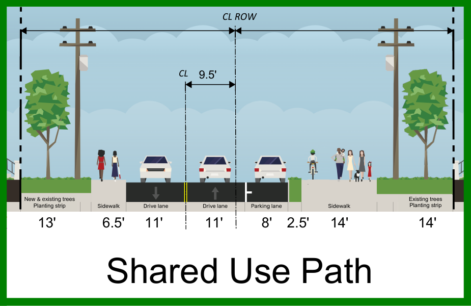
Builds a 14‑foot‑wide shared path for walking and biking on the south side
Adds a sidewalk along the north side, so pedestrians have options on both sides
Includes a buffer between traffic and people walking and biking on the shared path
Differs from the Bicycle Master Plan design but still offers similar safety and comfort
Does not require full roadway reconstruction, reducing construction time and impacts
Provides fewer on‑street parking spaces than Option A
Minimizes property impacts and saves about $1.5 million compared to Option A
Builds a 14‑foot‑wide shared path for walking and biking on the south side
Adds a sidewalk along the north side, so pedestrians have options on both sides
Includes a buffer between traffic and people walking and biking on the shared path
Differs from the Bicycle Master Plan design but still offers similar safety and comfort
Does not require full roadway reconstruction, reducing construction time and impacts
Provides fewer on‑street parking spaces than Option A
Minimizes property impacts and saves about $1.5 million compared to Option A