Lincoln-Lakeway Multimodal Transportation Study
This engagement has concluded
NEW! FINAL REPORT
- Explore the improvement recommendations below!
- View summary of feedback and staff responses.
PROJECT SUMMARY
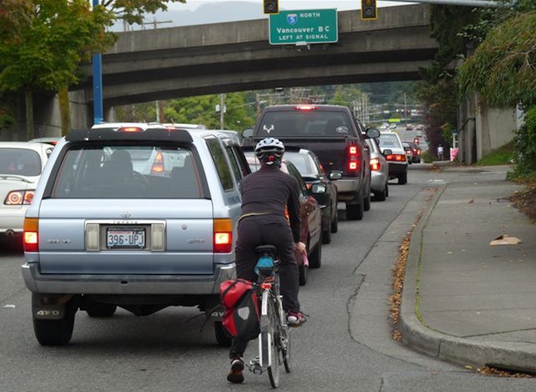
The City, Whatcom Transportation Authority (WTA), Washington State Department of Transportation (WSDOT), Whatcom Council of Governments (WCOG) and TranspoGroup consultants are collaborating on a comprehensive multimodal transportation study for the area between the Samish/I-5 and Iowa/I-5 interchanges and the Samish-Maple-Ellis corridor and the Puget-Lakeway-Lincoln corridor (see map below). The purpose is to document existing land uses, known development proposals, and land supply, then measure and analyze vehicular traffic impacts and travel demand for people walking, biking, and riding transit.
Analysis of alternativesContinue reading
NEW! FINAL REPORT
- Explore the improvement recommendations below!
- View summary of feedback and staff responses.
PROJECT SUMMARY
The City, Whatcom Transportation Authority (WTA), Washington State Department of Transportation (WSDOT), Whatcom Council of Governments (WCOG) and TranspoGroup consultants are collaborating on a comprehensive multimodal transportation study for the area between the Samish/I-5 and Iowa/I-5 interchanges and the Samish-Maple-Ellis corridor and the Puget-Lakeway-Lincoln corridor (see map below). The purpose is to document existing land uses, known development proposals, and land supply, then measure and analyze vehicular traffic impacts and travel demand for people walking, biking, and riding transit.
Analysis of alternatives for long-term changes to existing vehicle traffic circulation in the vicinity of the Lakeway/I-5 interchange and the potential consolidation and/or relocation of vehicular driveways along a portion of Lincoln Street will be included in this study. The project team will engage the public in various ways and seek input over the course of the study. Ultimately, both short-term and long-term multimodal transportation system improvements will be identified and recommended, which will allow Public Works to program local funding and to seek state and federal grant funding for construction in future years. Visit the Lincoln-Lakeway Multimodal Transportation Project Page for additional information.
Click map below to explore the study area in detail.

Please feel free to ask questions or make comments about the recommendations up until September 23, 2021.
This engagement has concluded
Ask a question and one of the staff from this multiagency study will provide a response as soon as possible.
-
Share Have you looked at the city of Spokane and their bike solution on very very busy, high traffic Division Street in the north end of Spokane. They have posted signs which require bicycles to ONLY use the sidewalk. This is a cheap solution to part of the Lakeway problem. Narrowing or reducing car lanes is just scary. As it is now on Chestnut, with 1 less lane, cars speed up in the left lane and then quickly cut into the middle lane before the traffic light which is dangerous and causing road rage. We don't need that on Lakeway which is even busier! on Facebook Share Have you looked at the city of Spokane and their bike solution on very very busy, high traffic Division Street in the north end of Spokane. They have posted signs which require bicycles to ONLY use the sidewalk. This is a cheap solution to part of the Lakeway problem. Narrowing or reducing car lanes is just scary. As it is now on Chestnut, with 1 less lane, cars speed up in the left lane and then quickly cut into the middle lane before the traffic light which is dangerous and causing road rage. We don't need that on Lakeway which is even busier! on X (formerly Twitter) Share Have you looked at the city of Spokane and their bike solution on very very busy, high traffic Division Street in the north end of Spokane. They have posted signs which require bicycles to ONLY use the sidewalk. This is a cheap solution to part of the Lakeway problem. Narrowing or reducing car lanes is just scary. As it is now on Chestnut, with 1 less lane, cars speed up in the left lane and then quickly cut into the middle lane before the traffic light which is dangerous and causing road rage. We don't need that on Lakeway which is even busier! on Linkedin Email Have you looked at the city of Spokane and their bike solution on very very busy, high traffic Division Street in the north end of Spokane. They have posted signs which require bicycles to ONLY use the sidewalk. This is a cheap solution to part of the Lakeway problem. Narrowing or reducing car lanes is just scary. As it is now on Chestnut, with 1 less lane, cars speed up in the left lane and then quickly cut into the middle lane before the traffic light which is dangerous and causing road rage. We don't need that on Lakeway which is even busier! link
Have you looked at the city of Spokane and their bike solution on very very busy, high traffic Division Street in the north end of Spokane. They have posted signs which require bicycles to ONLY use the sidewalk. This is a cheap solution to part of the Lakeway problem. Narrowing or reducing car lanes is just scary. As it is now on Chestnut, with 1 less lane, cars speed up in the left lane and then quickly cut into the middle lane before the traffic light which is dangerous and causing road rage. We don't need that on Lakeway which is even busier!
Oma3 asked over 5 years agoThe multi-agency project team will consider all options for providing physical space and facilities for all users on Lakeway Drive before making any recommendations for future improvements. With limited physical space available in some places, changes and compromises may be required and some options may not be financially feasible.
-
Share I can't get the pins to work, but want to register my agreement with the people saying that we need to definitely not reduce traffic lanes on Lincoln or Lakeway. I'm all for adding bike lanes but not for reducing the traffic leaves we already have. I do believe that would actually decrease safety. Also, making skinny lanes and opening to bikes is actually agist and ablist and I don't feel that the city is considering this. Do you have persons with disabilities and elderly people who rely on cars on your committees? are you working closely on their needs or only on young people who ride bikes needs? on Facebook Share I can't get the pins to work, but want to register my agreement with the people saying that we need to definitely not reduce traffic lanes on Lincoln or Lakeway. I'm all for adding bike lanes but not for reducing the traffic leaves we already have. I do believe that would actually decrease safety. Also, making skinny lanes and opening to bikes is actually agist and ablist and I don't feel that the city is considering this. Do you have persons with disabilities and elderly people who rely on cars on your committees? are you working closely on their needs or only on young people who ride bikes needs? on X (formerly Twitter) Share I can't get the pins to work, but want to register my agreement with the people saying that we need to definitely not reduce traffic lanes on Lincoln or Lakeway. I'm all for adding bike lanes but not for reducing the traffic leaves we already have. I do believe that would actually decrease safety. Also, making skinny lanes and opening to bikes is actually agist and ablist and I don't feel that the city is considering this. Do you have persons with disabilities and elderly people who rely on cars on your committees? are you working closely on their needs or only on young people who ride bikes needs? on Linkedin Email I can't get the pins to work, but want to register my agreement with the people saying that we need to definitely not reduce traffic lanes on Lincoln or Lakeway. I'm all for adding bike lanes but not for reducing the traffic leaves we already have. I do believe that would actually decrease safety. Also, making skinny lanes and opening to bikes is actually agist and ablist and I don't feel that the city is considering this. Do you have persons with disabilities and elderly people who rely on cars on your committees? are you working closely on their needs or only on young people who ride bikes needs? link
I can't get the pins to work, but want to register my agreement with the people saying that we need to definitely not reduce traffic lanes on Lincoln or Lakeway. I'm all for adding bike lanes but not for reducing the traffic leaves we already have. I do believe that would actually decrease safety. Also, making skinny lanes and opening to bikes is actually agist and ablist and I don't feel that the city is considering this. Do you have persons with disabilities and elderly people who rely on cars on your committees? are you working closely on their needs or only on young people who ride bikes needs?
Maireen asked over 5 years agoClick on the map, then in the upper left corner, click on the black circle with a plus sign, select the pin for the facility type (black for vehicle lanes), drag the pin to the correct map location, place the pin on the map, and enter the comment that you would like to make regarding vehicle lanes. Please read the Community Survey Final Report to see considerations regarding the City’s intent to ensure compliance with the federal Americans with Disabilities Act (ADA), as well as public opinion regarding where ADA upgrades are needed. Future recommendations for improvements in the Lincoln-Lakeway Study area will also be informed by both the City ADA Transition Plan (2021) and WTA’s long-range transit plan (WTA 2040).
-
Share Thank you for this opportunity to engage. I'm working on my thoughts on this and wonder how long this will be page will be open for comments? on Facebook Share Thank you for this opportunity to engage. I'm working on my thoughts on this and wonder how long this will be page will be open for comments? on X (formerly Twitter) Share Thank you for this opportunity to engage. I'm working on my thoughts on this and wonder how long this will be page will be open for comments? on Linkedin Email Thank you for this opportunity to engage. I'm working on my thoughts on this and wonder how long this will be page will be open for comments? link
Thank you for this opportunity to engage. I'm working on my thoughts on this and wonder how long this will be page will be open for comments?
Cindy asked over 5 years agoThis interactive Engage Bellingham site for the project was launched January 20, 2021 and is the latest opportunity for the public to participate in this important multi-agency study, in addition to email comments, the community survey with 558 responses, and comments received at online Neighborhood meetings. On March 1, 2021, we will stop allowing new map pins with comments so that we can compile all input up to that point and use it in our evaluation of the feasibility for future improvement scenarios. This will take some time, but when ready, these future improvement scenarios will be posted to the Engage Bellingham site and all project participants will be notified of their availability for review and comment. If you have further questions about this, please contact City Transportation Planner Chris Comeau directly at ccomeau@cob.org
-
Share I am wanting to add a comment to the Lakeway freeway underpass to not make changes that reduce the number of vehicle traffic lanes in the limited space. However, when I go to the map and look for the appropriate icon, there is none. The message is clear; this is a project that is intended to enhance bike traffic, and bus traffic, but nothing to deal with improving traffic flow other than to add vehicle turn lanes. If it were, the comment map would have an icon option for making such suggestions. on Facebook Share I am wanting to add a comment to the Lakeway freeway underpass to not make changes that reduce the number of vehicle traffic lanes in the limited space. However, when I go to the map and look for the appropriate icon, there is none. The message is clear; this is a project that is intended to enhance bike traffic, and bus traffic, but nothing to deal with improving traffic flow other than to add vehicle turn lanes. If it were, the comment map would have an icon option for making such suggestions. on X (formerly Twitter) Share I am wanting to add a comment to the Lakeway freeway underpass to not make changes that reduce the number of vehicle traffic lanes in the limited space. However, when I go to the map and look for the appropriate icon, there is none. The message is clear; this is a project that is intended to enhance bike traffic, and bus traffic, but nothing to deal with improving traffic flow other than to add vehicle turn lanes. If it were, the comment map would have an icon option for making such suggestions. on Linkedin Email I am wanting to add a comment to the Lakeway freeway underpass to not make changes that reduce the number of vehicle traffic lanes in the limited space. However, when I go to the map and look for the appropriate icon, there is none. The message is clear; this is a project that is intended to enhance bike traffic, and bus traffic, but nothing to deal with improving traffic flow other than to add vehicle turn lanes. If it were, the comment map would have an icon option for making such suggestions. link
I am wanting to add a comment to the Lakeway freeway underpass to not make changes that reduce the number of vehicle traffic lanes in the limited space. However, when I go to the map and look for the appropriate icon, there is none. The message is clear; this is a project that is intended to enhance bike traffic, and bus traffic, but nothing to deal with improving traffic flow other than to add vehicle turn lanes. If it were, the comment map would have an icon option for making such suggestions.
Joseph Wilson asked over 5 years agoPlease see the previous answer about this. You may place a black pin for vehicle improvements at your location of interest and then add the specific comment that you would like regarding vehicle traffic flow. We consider all comments, but the recommendations for improvements will be made based on what is financially feasible to help balance the transportation system for all users, not just cars. If you would like to discuss this further, you may contact City Transportation Planner Chris Comeau at ccomeau@cob.org
-
Share I am new to this page so I apologize if the answer is on here somewhere and I just have not yet found it. In regards to the Lakeway underpass, does this project widen it at all? I found on the map where I have the option to suggest adding bike lanes, but no option of adding vehicle lanes, or adding bike lanes without sacrificing vehicle lanes. And then a related question, could this project include a new freeway underpass or tunnel for bikes and pedestrians so the already limited Lakeway underpass is not further restricted by new bike lanes? on Facebook Share I am new to this page so I apologize if the answer is on here somewhere and I just have not yet found it. In regards to the Lakeway underpass, does this project widen it at all? I found on the map where I have the option to suggest adding bike lanes, but no option of adding vehicle lanes, or adding bike lanes without sacrificing vehicle lanes. And then a related question, could this project include a new freeway underpass or tunnel for bikes and pedestrians so the already limited Lakeway underpass is not further restricted by new bike lanes? on X (formerly Twitter) Share I am new to this page so I apologize if the answer is on here somewhere and I just have not yet found it. In regards to the Lakeway underpass, does this project widen it at all? I found on the map where I have the option to suggest adding bike lanes, but no option of adding vehicle lanes, or adding bike lanes without sacrificing vehicle lanes. And then a related question, could this project include a new freeway underpass or tunnel for bikes and pedestrians so the already limited Lakeway underpass is not further restricted by new bike lanes? on Linkedin Email I am new to this page so I apologize if the answer is on here somewhere and I just have not yet found it. In regards to the Lakeway underpass, does this project widen it at all? I found on the map where I have the option to suggest adding bike lanes, but no option of adding vehicle lanes, or adding bike lanes without sacrificing vehicle lanes. And then a related question, could this project include a new freeway underpass or tunnel for bikes and pedestrians so the already limited Lakeway underpass is not further restricted by new bike lanes? link
I am new to this page so I apologize if the answer is on here somewhere and I just have not yet found it. In regards to the Lakeway underpass, does this project widen it at all? I found on the map where I have the option to suggest adding bike lanes, but no option of adding vehicle lanes, or adding bike lanes without sacrificing vehicle lanes. And then a related question, could this project include a new freeway underpass or tunnel for bikes and pedestrians so the already limited Lakeway underpass is not further restricted by new bike lanes?
Joseph Wilson asked over 5 years agoYou are welcome to place a pin on the map and add these comments. Blue pins for bike improvements, black pins for vehicle improvements. We have not yet made any specific recommendations for transportation improvements as we are beginning feasibility analysis of what that might look like. Feasibility is determined based on a combination of constructability, cost, and financial resources available. As you might imagine, widening a freeway underpass or boring a tunnel beneath the freeway for people walking and biking would cost tens of millions of dollars, which neither the City nor WSDOT has available in the foreseeable future.
Chris Comeau, City of Bellingham Transportation Planner
-
Share Is it possible for the neighborhood on West and East Racine get a light on our blind corner to get onto Lakeway safely. If your not aware, its a blind corner we have to pull up to the bike lane to even see if that of on coming traffic. If your not aware the speed limit is 25 on Lakeway till our street Racine then 30 but people drive 50 at Puget Street all the way to Yew Street. It makes it impossible to get on the street. on Facebook Share Is it possible for the neighborhood on West and East Racine get a light on our blind corner to get onto Lakeway safely. If your not aware, its a blind corner we have to pull up to the bike lane to even see if that of on coming traffic. If your not aware the speed limit is 25 on Lakeway till our street Racine then 30 but people drive 50 at Puget Street all the way to Yew Street. It makes it impossible to get on the street. on X (formerly Twitter) Share Is it possible for the neighborhood on West and East Racine get a light on our blind corner to get onto Lakeway safely. If your not aware, its a blind corner we have to pull up to the bike lane to even see if that of on coming traffic. If your not aware the speed limit is 25 on Lakeway till our street Racine then 30 but people drive 50 at Puget Street all the way to Yew Street. It makes it impossible to get on the street. on Linkedin Email Is it possible for the neighborhood on West and East Racine get a light on our blind corner to get onto Lakeway safely. If your not aware, its a blind corner we have to pull up to the bike lane to even see if that of on coming traffic. If your not aware the speed limit is 25 on Lakeway till our street Racine then 30 but people drive 50 at Puget Street all the way to Yew Street. It makes it impossible to get on the street. link
Is it possible for the neighborhood on West and East Racine get a light on our blind corner to get onto Lakeway safely. If your not aware, its a blind corner we have to pull up to the bike lane to even see if that of on coming traffic. If your not aware the speed limit is 25 on Lakeway till our street Racine then 30 but people drive 50 at Puget Street all the way to Yew Street. It makes it impossible to get on the street.
Toolmom asked over 5 years agoRacine Street is beyond the Lincoln-Lakeway Study area boundary. For a comprehensive answer to your inquiry about a new traffic signal at Lakeway/Racine, please email City Transportation Planner Chris Comeau directly at ccomeau@cob.org
-
Share Possible to eliminate the free turn on red from BM Parkway heading east onto Samish Way. Would eliminate the lane blockage and reduce the traffic getting stuffed on Samish headed south. The second mesh is the free right from I5 south exit onto Samish Way and then trying to turn up the hill on BM towards the schools. Or a possible "do not block the box" marked intersection to eliminate the free turn folks blocking intersection and lanes. on Facebook Share Possible to eliminate the free turn on red from BM Parkway heading east onto Samish Way. Would eliminate the lane blockage and reduce the traffic getting stuffed on Samish headed south. The second mesh is the free right from I5 south exit onto Samish Way and then trying to turn up the hill on BM towards the schools. Or a possible "do not block the box" marked intersection to eliminate the free turn folks blocking intersection and lanes. on X (formerly Twitter) Share Possible to eliminate the free turn on red from BM Parkway heading east onto Samish Way. Would eliminate the lane blockage and reduce the traffic getting stuffed on Samish headed south. The second mesh is the free right from I5 south exit onto Samish Way and then trying to turn up the hill on BM towards the schools. Or a possible "do not block the box" marked intersection to eliminate the free turn folks blocking intersection and lanes. on Linkedin Email Possible to eliminate the free turn on red from BM Parkway heading east onto Samish Way. Would eliminate the lane blockage and reduce the traffic getting stuffed on Samish headed south. The second mesh is the free right from I5 south exit onto Samish Way and then trying to turn up the hill on BM towards the schools. Or a possible "do not block the box" marked intersection to eliminate the free turn folks blocking intersection and lanes. link
Possible to eliminate the free turn on red from BM Parkway heading east onto Samish Way. Would eliminate the lane blockage and reduce the traffic getting stuffed on Samish headed south. The second mesh is the free right from I5 south exit onto Samish Way and then trying to turn up the hill on BM towards the schools. Or a possible "do not block the box" marked intersection to eliminate the free turn folks blocking intersection and lanes.
PSA asked over 5 years agoThese are great questions, but unfortunately there are no easy answers. We've looked at possible improvements to these two closely spaced traffic signals, including a series of three roundabouts (2009), and intersection widening at Samish/Bill McDonald to put in a dedicated right-turn lane (2017). Restricting right-turns does not prevent the turn lanes from filling up from other turning movements. The problem at this location is too many people all wanting to be at the same place at the same time (demand exceeding supply), many in single-occupancy vehicles, but many also riding WTA buses between WWU and the Lincoln Creek Transportation Center. We will continue to explore ideas to make improvements at these intersections, but until we can change the demand side of the equation, it will be difficult. I will ask our Bellingham Police Department about the "Block the Box" enforcement, which is done in Seattle and other cities, but that may be a Police time and resource issue more than an infrastructure issue.
Signup Banner

Who's Listening
-
Phone 360-778-7946 Email ccomeau@cob.org -
Email timw@ridewta.com -
Email shambaj@wsdot.wa.gov -
Email hugh@wcog.org
Timeline of Major Study Components
-
Study Initiated: March 2020
Lincoln-Lakeway Multimodal Transportation Study has finished this stage -
Community Survey: May 11 - June 1, 2020
Lincoln-Lakeway Multimodal Transportation Study has finished this stageView Press Release and Community Survey Results
-
Neighborhood Meetings: October - December 2020
Lincoln-Lakeway Multimodal Transportation Study has finished this stageOctober 8, 2020: Samish Neighborhood Association (presentation link)
October 28, York Neighborhood Association (presentation link)
December 8, 2020: Puget Neighborhood Association (presentation link)
-
Analyze Existing Transportation Conditions: April - December 2020
Lincoln-Lakeway Multimodal Transportation Study has finished this stage -
Analyze Transportation Improvement Scenarios: January - May 2021
Lincoln-Lakeway Multimodal Transportation Study has finished this stageAnalyze cost-benefit of short-term and mid-term improvements to arterial streets and intersections and feasibility of long-term changes surrounding the Lakeway/I-5 interchange.
-
Multi-Agency Collaboration & Review of Improvement Scenarios: June-July 2021
Lincoln-Lakeway Multimodal Transportation Study has finished this stageMulti-Agency review of improvement scenario options and issues; Multi-Agency meeting June 11, 2021; Multi-Agency field investigation of existing conditions at Lakeway/I-5 interchange, multiple signalized intersections on Lakeway Drive, and the Lincoln-Meador corridor.
-
Transportation Commission: October 12, 2021
Lincoln-Lakeway Multimodal Transportation Study is currently at this stage6:15 pm
Email Updates
To sign up to receive emails about this project, contact Chris Comeau at ccomeau@cob.org.