Lincoln-Lakeway Multimodal Transportation Study
This engagement has concluded
NEW! FINAL REPORT
- Explore the improvement recommendations below!
- View summary of feedback and staff responses.
PROJECT SUMMARY
The City, Whatcom Transportation Authority (WTA), Washington State Department of Transportation (WSDOT), Whatcom Council of Governments (WCOG) and TranspoGroup consultants are collaborating on a comprehensive multimodal transportation study for the area between the Samish/I-5 and Iowa/I-5 interchanges and the Samish-Maple-Ellis corridor and the Puget-Lakeway-Lincoln corridor (see map below). The purpose is to document existing land uses, known development proposals, and land supply, then measure and analyze vehicular traffic impacts and travel demand for people walking, biking, and riding transit.
Analysis of alternativesContinue reading

This engagement has concluded
-
Overview & Introduction to Improvement Recommendations
Share Overview & Introduction to Improvement Recommendations on Facebook Share Overview & Introduction to Improvement Recommendations on Twitter Share Overview & Introduction to Improvement Recommendations on Linkedin Email Overview & Introduction to Improvement Recommendations linkWatch the video below to learn more about this project. Make sure to also watch the site specific recommendation videos below!
View summary of all feedback and staff responses.
Commenting on the recommendations will be available until September 23, 2021.
 7 comments
-
LINCOLN ST: James/Meador to Lakeway Drive
Share LINCOLN ST: James/Meador to Lakeway Drive on Facebook Share LINCOLN ST: James/Meador to Lakeway Drive on Twitter Share LINCOLN ST: James/Meador to Lakeway Drive on Linkedin Email LINCOLN ST: James/Meador to Lakeway Drive linkWatch the video below to learn more about the specific recommendations in this area. Leave your feedback below!
View summary of all feedback and staff responses.
Commenting on the recommendations will be available until September 23, 2021.
-
LINCOLN ST: Lakeway Drive to E Maple Street
Share LINCOLN ST: Lakeway Drive to E Maple Street on Facebook Share LINCOLN ST: Lakeway Drive to E Maple Street on Twitter Share LINCOLN ST: Lakeway Drive to E Maple Street on Linkedin Email LINCOLN ST: Lakeway Drive to E Maple Street linkWatch the video below to learn more about the specific recommendations in this area. Leave your feedback below!
View summary of all feedback and staff responses.
Commenting on the recommendations will be available until September 23, 2021.
-
LAKEWAY DR: Puget St to Lincoln St
Share LAKEWAY DR: Puget St to Lincoln St on Facebook Share LAKEWAY DR: Puget St to Lincoln St on Twitter Share LAKEWAY DR: Puget St to Lincoln St on Linkedin Email LAKEWAY DR: Puget St to Lincoln St linkWatch the video below to learn more about the specific recommendations in this area. Leave your feedback below!
View summary of all feedback and staff responses.
Commenting on the recommendations will be available until September 23, 2021.
-
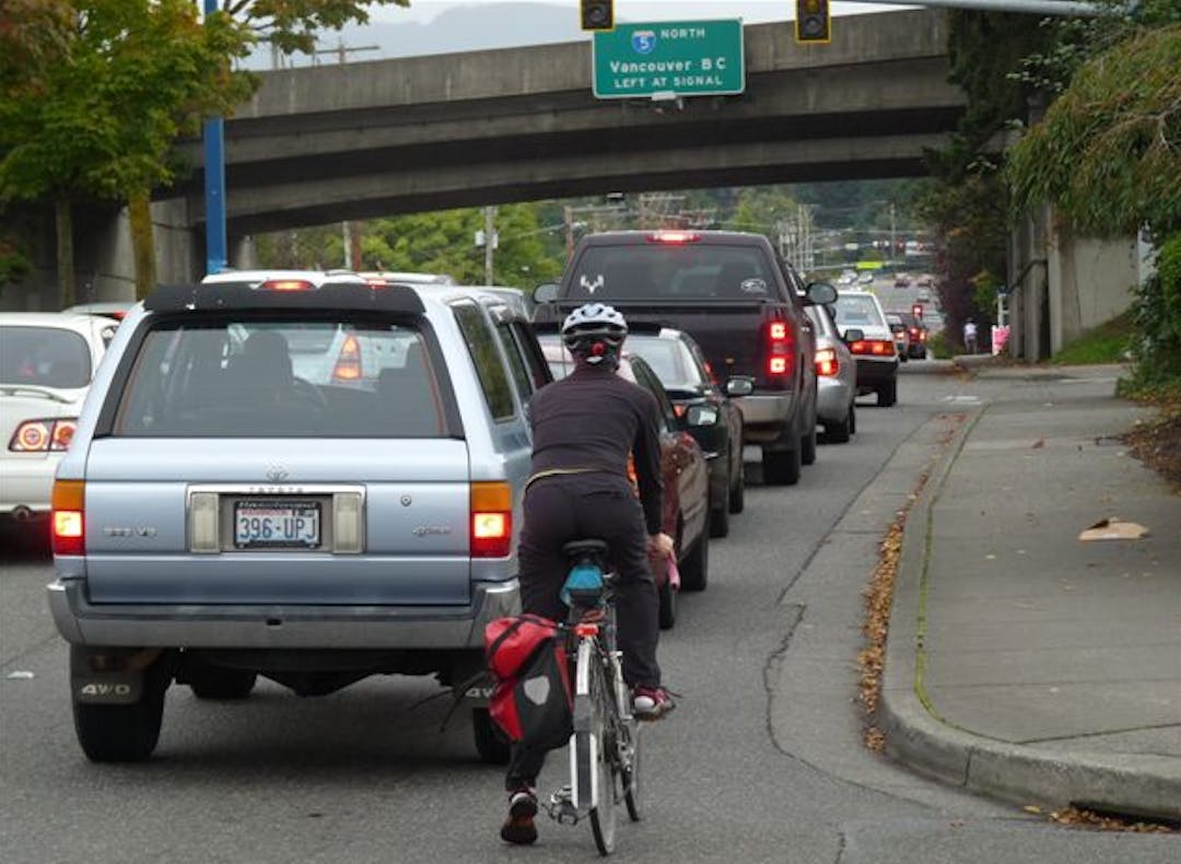
LAKEWAY DR: Lincoln St to I-5 Underpass
Share LAKEWAY DR: Lincoln St to I-5 Underpass on Facebook Share LAKEWAY DR: Lincoln St to I-5 Underpass on Twitter Share LAKEWAY DR: Lincoln St to I-5 Underpass on Linkedin Email LAKEWAY DR: Lincoln St to I-5 Underpass linkWatch the video below to learn more about the specific recommendations in this area. Leave your feedback below!
View summary of all feedback and staff responses.
Commenting on the recommendations will be available until September 23, 2021.
-
LAKEWAY DR: I-5 to Ellis St
Share LAKEWAY DR: I-5 to Ellis St on Facebook Share LAKEWAY DR: I-5 to Ellis St on Twitter Share LAKEWAY DR: I-5 to Ellis St on Linkedin Email LAKEWAY DR: I-5 to Ellis St linkWatch the video below to learn more about the specific recommendations in this area. Leave your feedback below!
View summary of all feedback and staff responses.
Commenting on the recommendations will be available until September 23, 2021.
-
King St, Potter St and I-5 on/off ramps
Share King St, Potter St and I-5 on/off ramps on Facebook Share King St, Potter St and I-5 on/off ramps on Twitter Share King St, Potter St and I-5 on/off ramps on Linkedin Email King St, Potter St and I-5 on/off ramps linkWatch the video below to learn more about the specific recommendations in this area. Leave your feedback below!
View summary of all feedback and staff responses.
Commenting on the recommendations will be available until September 23, 2021.
 7 comments
Signup Banner

Who's Listening
-
Phone 360-778-7946 Email ccomeau@cob.org -
Email timw@ridewta.com -
Email shambaj@wsdot.wa.gov -
Email hugh@wcog.org